Cowesfield Nursery
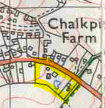
Cowesfield Nursery was already running as a Nursery on the south side of the A27 Romsey Road by 1885 and had taken the name Cowesfield Nurseries by 1966. It was opposite Chalkpit Farm and the entrance to the Pains firework factory. The original house on the site was built in the late nineteenth century, probably incorporating a smaller building that had stood there already in 1885, and was renamed from Cowesfield Nurseries to Country Cottage in about 2000. Old Nursery House was built next door between 1966 and 1978 on part of the nursery site, almost certainly after the nursery had moved to a new location further down the hill and opened as Woodlands Nursery, now Courtens Garden Centre.
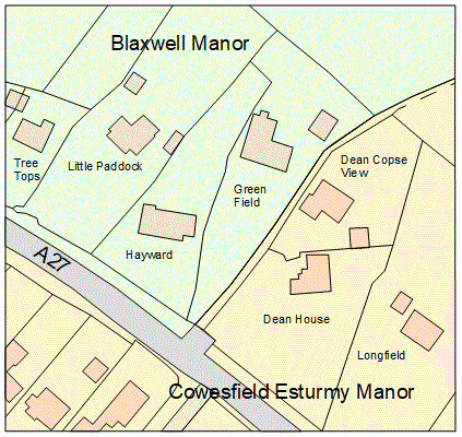
The name certainly deserves an explanation. While the nursery was situated well within Cowesfield Esturmy manor, we no longer think of this part of Whiteparish as being Cowesfield. In fact Cowesfield Esturmy manor contained not just the nursery but all the land on the south side of the A27 up to and including the Parish Lantern pub. On the north side of the A27, the footpath running between Hayward/Greenfield and Dean House/Dean Copse View marks the boundary between Cowesfield Esturmy and Blaxwell manors, so travelling towards Romsey all the properties on the left side of Romsey Road from Dean House onwards were part of Cowesfield Esturmy, including Meadow Court and the Great Dean field behind it. Travelling towards Romsey on the A27, Cowesfield Spilman, the second of the three Cowesfield manors, begins at Miles Lane.
 .
. 
Left: The boundary between Cowesfield Esturmy and Blaxwell on the Romsey Road at Dean House
Blaxwell top left, Cowesfield Esturmy bottom right
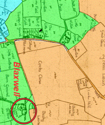
Right: Blaxwell: green and Cowesfield Esturmy: buff on the 1842 Tithe Map (Alderstone manor is blue)
Cowesfield Nursery/Nurseries was still named as such when I moved to Whiteparish in 1983 and for a long time afterwards. The move to the Courtens Garden Centre site appears to have taken place between 1970 and 1974.
In Whiteparish 100 years (page 113) Mrs Portnall recalled from the 1920s and 1930s that her great uncle Thomas Giles lived in Cowesfield Nursery and ran a market garden, also supplying flowers for weddings and wreaths.
The first map below shows the nursery on a map published in 1885, although I don't yet know how long it had been there by then.

The Nursery on OS map surveyed 1872-1879, published 1885 (1885 1:10,560 doesn't have the nursery)
By 1901 the house had been added that was later called Cowesfield Nurseries and is now Country Cottage.

The context of the nursery on the 1901 1:2500 map
The 1925 map shows a third greenhouse had been added, conveniently confirming that the two buildings on the 1901 map were greenhouses.
Cowesfield Nursery in 1925
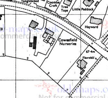
By 1966 the house called Thornhill had been built on part of the nursery land adjacent to the public footpath to Blackwell. Thornhill was demolished in [c2000?] and two houses, Melcombe and Wykeham House, now stand on this plot. Next door to this coming up the hill, three new houses were constructed on the next section of the Nursery land: Swallowfields, Springfield and Barlinka. Other houses have also filled the gap between the Parish Lantern and Old Nursery House, as well as Raycott and Summer Lodge alongside Country Cottage.

Cowesfield Nursery in 1966
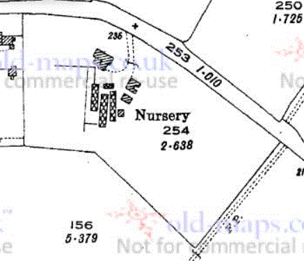
The 1978 map below still shows the nursery, although as noted above, I believe it had already moved by that date.
Cowesfield Nursery in 1978

The wider setting of the Nurseries on the 1978 1:2500 map
The final map here shows a modern view of the land occupied by the nursery, divided into smaller plots with a house on each and the nursery still present on a much reduced site.

The Cowesfield Nursery site in 2025, now occupied by the houses from Old Nursery House to Wykeham House and Melcombe
The public footpath to Blaxwell can be seen bottom right, labelled 'track'
Woodlands Nursery, now Courtens
At the time Cowesfield Nursery was being divided up and sold, a new nursery, Woodlands Nursery, was developed on the site that is now Courtens, opposite Long Pond. Both were shown on 1978 maps but the new one had not been there in 1966. Whether the two are related is yet to be determined.
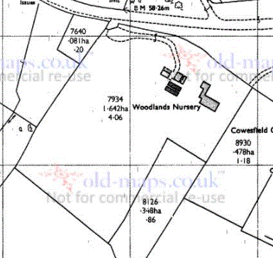
Woodlands Nursery in 1978